Category: Mashadi History

  • Mapping Eidgah: An Interactive Record of the Jewish Quarter of Mashad

    Mapping Eidgah: An Interactive Record of the Jewish Quarter of Mashad

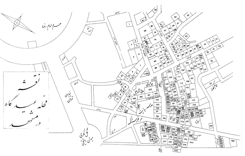
    Walk through Eidgah, the Jewish quarter of Mashad, today and many, if not most, of its main streets are still there. What has changed is what stands along them. The small alleyways that once ran between the houses are largely gone, and the buildings themselves have been redeveloped so completely that few of the original structures remain. You can still walk the streets our families walked; you can rarely stand in the houses they lived in. This map shows where those original buildings stood.

    What the buildings were, who lived in each, and how each was used survives in the record. The fullest single document of the quarter is a detailed plan, drawn around the turn of the twentieth century, showing 243 numbered parcels, each one a household, a courtyard, a synagogue, a school, or a shop. That plan, together with the key identifying who lived in and used each parcel, was preserved and published in Two Centuries of Resistance: The History of Mashadi Jews, Volume I, compiled by Shlomo Kaboli for the United Mashadi Jewish Community of America.1 Nearly everything on this map comes from that volume; this project would not exist without it.

    What this project adds is organization and access. The parcels, names, and uses recorded in the book have been transcribed into a structured database, each lot has been traced and placed over present-day satellite imagery of Mashad, and the whole has been built into a single interactive map you can search and open on a phone. In other words, the documentation already existed; this project turns it into something you can use.

    You can open the map here:

    👉 map.mashadihistory.com


    What you can do with it

    • Search by family name. If a family’s name is attached to a parcel in the record, type it in and the map will take you to where that household stood.
    • Tap any parcel to see what is recorded about it: its number, its owner or use, and its name in both Persian and English.
    • “Find me.” If you are ever in Mashad near the shrine, the map can use your phone’s location to show where you are in relation to the old quarter.
    • Switch between satellite and street views, to see both the present-day buildings and the road grid that replaced the quarter.
    • Color-coding by type: homes, synagogues, schools, the public bath, shops, storage, and the cemetery each appear in their own color, so the shape of a whole community comes back into view.

    How accurate is it?

    Precision matters here, so it is worth being exact about what the map does and does not claim.

    The original plan was drawn by hand and not to scale. Its proportions are distorted in ways no single mathematical transform can correct: one block is compressed, the next stretched. To place it on real imagery, each block and all 243 parcels were traced individually and fitted block by block onto the modern streets, anchored at the few points that can still be verified on the ground.

    In practical terms, the map shows the right neighborhood and, block by block, very nearly the right place, but it is an approximation, not a survey. A given parcel may sit some meters from where its walls actually stood. Read it as “this is the corner where your family lived,” not “this is the exact square meter.” Where a placement is an estimate rather than a confirmed location, the map says so in the parcel’s own details.


    Places that still stand

    Almost all of the original buildings are gone, but not every one. A handful of structures appear to survive, and the map marks them.

    Two can be pointed to with confidence, since their identity and location are confirmed and you can see them:

    • Haji Ismail’s Bath House (Garmabe-ye Eslam), parcel 27: still standing, with a photograph of its interior on the map and a link to view it on the ground today.
    • The Azizollahoff Caravanserai, parcel 38: also standing, its restored timber galleries and brick arches still visible, likewise with a photo and a map link.

    Both of these link out to their Google Maps listings, where visitors have posted many more photographs than the map itself can hold: interiors, architectural details, and present-day views that are well worth exploring on your own.

    Three more places associated with named families appear to survive in some form, but I want to be clear that their identification and placement are our best estimate, not confirmed:

    • Nasrollah Hakim’s house (Karbalai Mohammad Safi), parcel 65
    • Farajollah Kashi’s house, parcel 102
    • The Ghafarzadeh house, parcel 103, known today as the Qafori House

    For these three, the Google Maps location is a careful estimate, and the map flags it as such. If you have firsthand knowledge of any of them, or know of other structures from the quarter that survive, that is exactly the kind of correction that makes this record better.


    What is still open

    This is a first version, and an honest record carries its open questions:

    • Some parcels are unnamed or uncertain. Not every household on the plan was recorded with a family name, and some readings are tentative.
    • The block-by-block fit can still improve as more points are confirmed on the ground.
    • Photographs and memories are missing. The map gives you the where; it cannot give you what the place was like.

    Contribute to the record

    This map is a working resource, not a finished monument. It improves every time someone supplies a correction, a name, a memory, or a photograph. If you find your family’s parcel, or find a mistake, please write in. Corrections are as valuable as discoveries, and both go back into the database for everyone.

    👉 map.mashadihistory.com


    Footnotes

    1. Shlomo Kaboli, comp., Two Centuries of Resistance: The History of Mashadi Jews, Vol. I (United Mashadi Jewish Community of America). The neighborhood plan and parcel key are reproduced in that volume (pp. 494-499); the parcel numbers, names, and recorded uses on this map are drawn from it.
  • A Hidden Treasure: A 1700s Letter from Jerusalem’s Great Rabbis to the Mashadi Community

    A Hidden Treasure: A 1700s Letter from Jerusalem’s Great Rabbis to the Mashadi Community

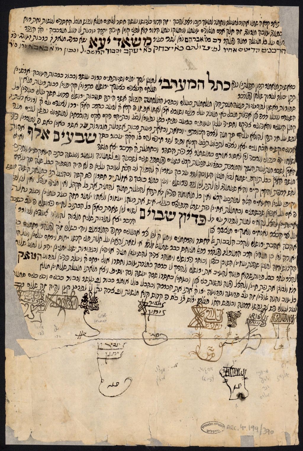
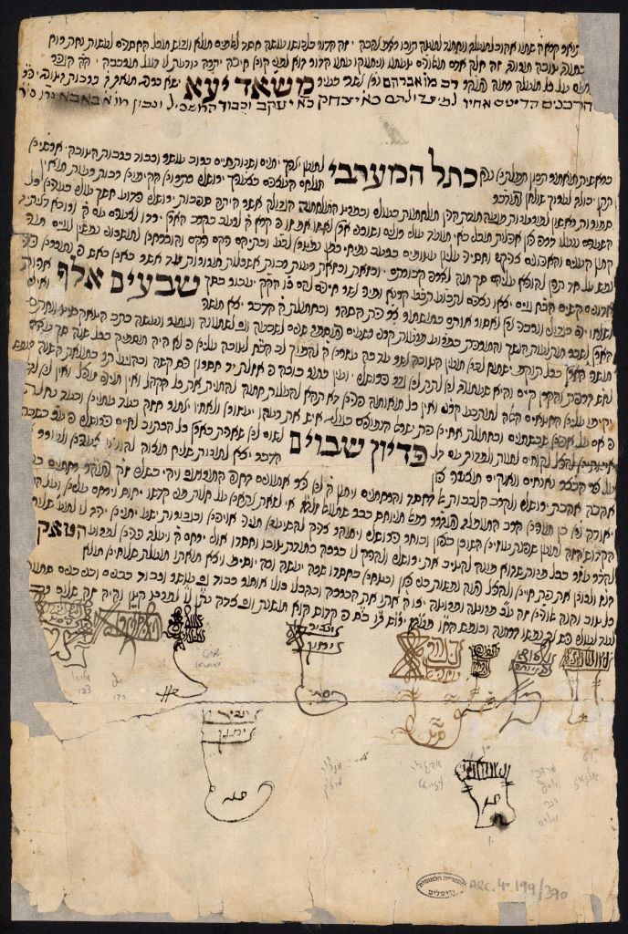
    While going through some archival material recently, I came across a historic letter1 that I believe very few, if any people in our community, or even in broader Mashadi research circles, were aware of. This letter was sent from the leading Sephardic rabbis of Jerusalem, dated in April/May 1776—names that carry incredible weight, like Rabbi Yom Tov Algazi and possibly Rabbi Moshe Yosef Mordechai Meyuchas (mistakenly identified as R’ Mordechai Yosef Meyuchas). And incredibly, it was addressed to our very own Mashadi Jewish community of Iran.

    That’s right. A direct connection between the spiritual center of Jerusalem and our then-young, somewhat remote community in Mashad, dating back over 200 years.

    The letter was written on behalf of a shelucha derabbanan (שד”ר)—a rabbinic emissary sent from the Holy Land to raise desperately needed funds for the Sephardic Jewish community in Jerusalem. The signatories include not just Rabbi Algazi and Rabbi Meyuchas, but also other rabbinic figures like Rabbi Yaakov L’vet Chazan, the Kabbalist Rabbi Avigdor Azriel, Rabbi Mansur Marzuk, Rabbi Shemuel Maimerman, Rabbi Refael Yosef Ben Robi, and Rabbi Eliyahu Tzvi.

    The language of the letter is respectful, and four Mashadi community members are mentioned by name. It reflects a connection that spanned thousands of miles across deserts and mountains. It shows us something remarkable: even in the 1700s, our community was on the radar of the great spiritual leaders of the time.


    Why This Matters

    This discovery opens a window into the untold relationships between the Mashadi Jewish community and the wider Jewish world.

    Our ancestors had only recently arrived in Mashad after being relocated from Qazvin and Deylaman. We were a small, developing community. And yet, the great rabbis of Jerusalem knew about us. They reached out to us. They trusted us to respond to the call to support Torah, community, and survival in the Holy Land.


    Analysis & Deeper Context

    What is a שד”ר (Shelucha DeRabanan)?
    In the 17th and 18th centuries, it was common for communities in Israel—especially Jerusalem, Tzfat, Tiberias, and Chevron—to send emissaries (שד”רים) to Jewish communities across the Middle East, North Africa, and even Europe. These emissaries were usually well-respected Torah scholars entrusted with raising funds to support the often-impoverished Jewish communities of the Land of Israel. Their letters of endorsement—like the one we found—were signed by the city’s rabbinic leadership to lend authority and credibility.

    Who Were These Rabbis?

    • Rabbi Yom Tov Algazi (1727–1802) was the Chief Rabbi of Jerusalem and one of the most prominent Sephardic figures of his time. He was the son of Rabbi Israel Yaakov Algazi and was known for his deep Torah knowledge and his leadership of the Jerusalem community.
    • Rabbi Moshe Yosef Mordechai Meyuchas (d. 1805) came from the famous Meyuchas family, known for its scholarship and service in Jerusalem for centuries. He was the Rishon Letziyon from 1802 – 1805. He authored Shaar HaMayim, Berachot Mayim, and Mayim Shaal.
    • Rabbi Yaakov L’vet Chazan, Rabbi Avigdor Azriel, and Rabbi Eliyahu Tzvi are less documented but were evidently key figures in Jerusalem’s rabbinic circles during this time.
    • Rabbi Mansur Marzuk, Rabbi Shemuel Maimerman, and Rabbi Refael Yosef Ben Robi appear in some Sephardic records as communal leaders and signatories on similar rabbinic letters.

    Their signatures together indicate this was not a casual note, but a serious and unified appeal—likely part of a coordinated fundraising effort.

    Unanswered Questions for Further Research

    1. Who were the individuals addressed in the letter?
      • Mollah Rav Avraham, his brother the dayan Rav Yitzchak, Yaakov, and Baba are mentioned with reverence.
        These may have been early leaders or philanthropists in our Mashadi community.
      • Do their names appear elsewhere in our records of the community at this time?
    2. How did these rabbis know about Mashad?
      Was there a connection between our community and the Rabbis of Jerusalem that we previously did not know about? We know from other sources that Rabbi Mollah Or Shraga of Yazd once sent a letter recommending a shelucha derabbanan from Chevron to the Mashadi community (more on this in a future post). So it seems the Jerusalem rabbis had some kind of correspondence or chain of communication—perhaps through the Jewish community in Yazd, or other communities in Iran.
    3. Why Mashad?
      Mashad wasn’t a large or rich community yet. The fact that we were chosen as recipients of this letter suggests that even in our early days, we had a reputation for generosity, for Torah support, and for being connected to the broader Jewish world.
    4. The name of the shelucha derabbanan is unclear. The letter does seem very similar to many others (like this letter designated for the city of Brody). Can it be the same emissary? An in depth translation and analysis of this letter, and comparisons with the eminent expert on shluchei derabbanan Avraham Yaari‘s book שלוחי ארץ ישראל may answer these questions, and more.

    Conclusion

    This letter is more than a piece of old paper. It’s a message across centuries. A reminder that we’ve always been part of a living chain of Jewish history. Our community has deep roots and historic connections. And there’s still so much more to uncover. Share your questions and comments below!

    Let’s keep uncovering our story.

    1. כתב שליחות לשד”ר רחמים בן יאודה בן רפאל בן שמואל מיוחס, אייר ה’תקל”ו, סימול ARC. 4* 199 / 390 אוסף תעודות שד”רים, אוסף תעודות שד”רים.; ↩︎

    A special thank you to Mr Lee Dilamanian for his insights and contributions.